Thursday night Chris, Jennifer, Paula, Jim, Anne, and I drove to Ashland for a night out. The evening needed a banner to fly, so it was decided we would celebrate Jim’s 70th birthday. Actually, Jim’s birthday had past nearly two weeks ago. He is a Valentine man. Anne had been visiting Judy in Los Vegas and St. George. It was Judy’s birthday, also. Anne had missed Jim’s special day and she wanted to make it up to him.
We began the evening with dinner at the Standing Stone Brewery. Two hours had been set aside for the meal. The ladies did a lot of catch-up, as did the guys. Chris briefed Jim on all the latest regarding Alpaca Guitar’s pending ventures south of the border. Chris is currently collecting venture capital commitments to do the manufacturing of Alpaca in Mexico. Chris also told Jim about his recently patented guitar tuner.
It had been a nice dinner, but we had tickets for the 8 o’clock presentation of “Ring of Fire” at the Cabernet Theater. Ring of Fire is a musical production presenting the story of Johnny Cash. Five musicians played and sung their way through Johnny’s good times, and bad. Between songs a short narrative was given and that narration tied the song to the period in Johnny’s life. When the two acts were over, there wasn’t a hum less throat in the building. Everyone had a great time.
Thursday evening’s fun on the town brought a well-deserved postponement of Rob & Anne’s next great RV adventure. We put off Friday’s departure for one day. There were some clothes to pack and we needed to visit the grocer. The bus had been readied. The bikes were securely locked onto the CRVs new tail hitch. I was positioned at, “T minus when you are ready.”
We pulled onto Hillcrest Road at 0900 hours, Saturday, February 27, 2016. The next stop: somewhere south of Red Bluff. Friday had been clear over the southern passes. The weekend was predicting storms, and maybe more snow. We would be topping Siskiyou Summit around late morning. If there were snow, the air temperatures would have warmed enough to have cleared the roads. We were in luck, no rain, and no snow.
We reached Corning, CA by mid-afternoon. Two hundred miles was enough for the day. Rolling Hills Casino & RV Park was an easy pull off from the freeway. This would be our second visiting to this RV Park. We quickly got our home setup for the night. I stayed behind while Anne paid a visit to the digitally modernized armless bandits.

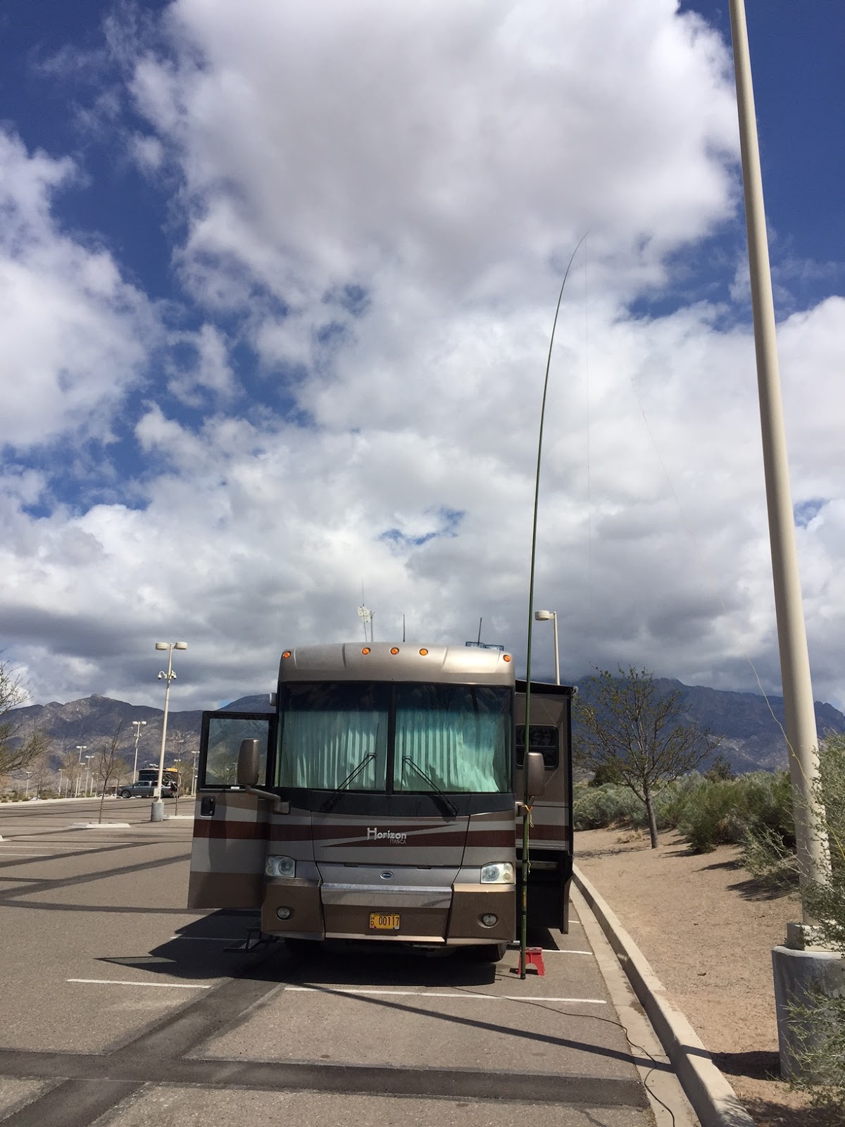
Chris has been an amateur radio operator for many years. He has encouraged me to get involved, but I couldn’t get off my duff. Since he has been with us, he has successfully lit a fire under both me, and Bill. We have both tested through the second level, General, and I have continued studying for the final level, the ham Extra license. The three of us have built and hung long wire antennas in the back yards. Bill and I have invested in some ham band radio gear, aka, rigs. I put together a mobile, battery operated kit that can travel with us in the RV, or it can be setup in the man-cave at home. When you have a ham radio in a room, that room is now called, in ham parlance, you shack.
We planned to drive about 200 miles again on Sunday. This day’s trip would take us south and east of Sacramento to a village called Angles Camp, named after Mr. Angle, who first settled there. To get to Angles Camp we skirted Sacramento, thank goodness, and drove up and down all of the hills that make up the foothills of the Sierra Nevada Range – or so it seemed. We have never seen greener, more lush California countryside. Spring is showing everywhere. It is sad that in a couple of months the hillsides will become brown during the drought-like conditions of the mid-California summer.
We passed through the town of Angles Camp and found Angles Camp RV Park at the junction

of Hwy 49 and the road which leads to Melones reservoir. The park has full hookups and site #3 was a drive through parking spot. We didn’t venture out of the camp tonight. Anne seemed satisfied that she had beaten me at pinochle and that we had decent satellite TV to watch.

of Hwy 49 and the road which leads to Melones reservoir. The park has full hookups and site #3 was a drive through parking spot. We didn’t venture out of the camp tonight. Anne seemed satisfied that she had beaten me at pinochle and that we had decent satellite TV to watch.
Our original plan for this trip was to spend the majority of our time diverse camping, or boondocking. This is RV camping without hookup amenities. The bus has a large diesel generator we can use for electrical needs. However, we rarely require its output capacity. We brought along a smaller, portable 2800 watt gas generator. It is sufficient to power lights, microwave, sewing machine, and TV. If we need air-conditioning, we will turn on the larger generator. The RV has a few weeks of propane, fresh water, and waste water storage capacity. A more gentile power source was the only extra thing we had needed. Now, we can boondock.
 There is an abundance of federally owned land in the west. With some codicils, virtually all of that land can be camped on, for free. Our target state is Arizona. The Bureau of Land Management, BLM, has set aside many sites for RVing. You can stay at each of them for up to 14 days. Chris and his family gave stayed at many of them and he gave us a link to Boondocker’s Guide to Arizona. That will be our bible for this trip.
It is Super Tuesday for the 2016 elections and we are up and on the road by 0900. A few miles of hilly, windy road southeast of Angle Camp is Columbia State Historic Park. The park is a section of the city of Columbia, CA that was set aside by the state in 1945. Columbia was put on the maps during the 19th century gold rush. It has the state’s largest collection of gold rush era buildings.
A brief stop to dry rain drenched clothes in 1850 led to one of California’s largest gold strikes. Beginning with the weather beaten, pass-through party of five, within a few weeks their gold finding had caused the camp to swell to several thousand miners. Columbia’s growth boomed over the next decade. By 1853 Columbia was one of the largest cities in California. Nearly 150 million dollars in gold was mined from Columbia. Much of this gold helped fund the Union Army during the U.S. Civil War.
Columbia never became a ghost town. Today, it is an active tourist city where the gold rush history can be relived at the saloon, or at the livery stable. The weather was wonderful, and the journey provided a good relief from the political ether which otherwise hung over Super Tuesday.
In Oregon, Hwy 199 takes you from Grants Pass to Hwy 101, which runs the entire western coast line. On the way, you track a windy road which runs alongside the beautiful Smith River. The
 water is crystal clear. Driving past the river always leads me to conjure thoughts of what it would be like to dive into the deep blue pools at the bottom of the riffles, tossed over granite boulders which had been laid to wash many millennia ago. At the bottom of the pools I anticipate finding hand’s full of gold nuggets. Then I snap out of it.

Highway 199 takes you past Redwood State Park. Northern California is host to the coastal redwood. This redwood is the world’s tallest tree. The tree has a life span of around 1,800 years. These historians have lived since the time of Christ. Their height would stretch the ground from goal post to well into the bleachers at the other end of a football field. California is also the only place where the second specie of redwood grows. The giant sequoia used to populate Asia and Europe. The sequoia, much protected, now lives on the foothills of the Sierra Nevada Mountains.
Wednesday we drove from Glory Hole Ironside RV Park, on the banks of the Melones Reservoir, into the foothills to Arnold, CA. Arnold is the entry point to Calaveras Big Tree State Park.
 In 1852 a miner was tracking a grizzly bear he had wounded. The trek took him through unfamiliar territory. He came upon a forest of enormous trees. The giant sequoia that caught his eye was the largest tree he had ever seen. The description of what he had come upon was considered a “tall tale”. The Discovery Tree, which had stopped the hunter in his tracks, was the forest’s first casualty. Some while later it had taken 5 men, 22 days to cut the tree down.
The coastal redwood is the world’s tallest tree. However, its southern cousin, the giant sequoia, is the world’s most massive tree. The sequoia is shorter, but it is a giant with its 25 plus feet of base diameter. We strolled along a two mile trail through the grove and we were left in awe with what we saw and learned. The sequoia trumps the coastal redwood in a second way. It is the world’s oldest tree. The sequoia has a life span of over 3,000 years. These trees had lived through the rise and fall of the Roman Empire. We had seen a lot of nature’s magic today. The sun was low in the west when we pulled into our site. It was time for a lazy evening.
Thursday was a day for travel. We chose Tule RV Park, on Success Lake, as our next stop. The lake is east of Porterville. We wanted to drive to Success Lake by way of US Hwy 99. However, getting onto Hwy 99 from Angles Camp was a slow, twisty, narrow, hilly bit of driving torture. There seemed to be a center line hugging truck coming around every blind corner. I looked for wide, pullover spots and let the train of trailing cars pass us by. Hwy 99S gracefully brought us onto the flatlands. The fields lining the road contained vast, budding orchards, and huge acres of lush, green grasses, which would soon be harvested as spring hay. Two lanes let us cruise at 55 mph. This speed permitted comfortable passage by the endless number of business busy freight trucks.


On the road leaving Porterville, Anne spotted a roadside fruit vendor. Anne pealed two of the delicious oranges as we navigated the last few miles to Success Lake. State highway 190 took us past the large, rock filled dam which held back the waters of the lake. We found no one at the check-in building, so we picked up a card and drove past many empty sites until we found one with a large expanse of lawn. Site #63 will do just fine.
I removed Anne’s bike from the rear of the CRV. She rode back to the entry building to pay for the site. We will stay at least two days. While she was gone, I got out the portable generator, set up the satellite antenna, and started laying out ground reflector wires for the vertical antenna. When Anne returned she grabbed her book and sat in the late afternoon sun at the picnic table. I finished setting up the antenna and retreated to the RV for a quick check of the afternoon radio traffic. Before sitting down, I snapped the tab on a chilled tinny. Yes. This was going to be a good evening.
Fox News was hosting the Republican debate this evening. Anne and I grimaced through several embattled minutes of the program. Trump and Rubio quickly began roughing each other up. The three commentators struggled to maintain decorum on the stage. Alas. I gave in first, and we settled on an old episode of “The Big Bang Theory”; while Anne’s casserole finished cooking.

Anne claims that she just throws whatever she has in the fridge together for the casserole. This was a yummy meal. After dinner Anne made cookies and I sat down to watch the Australian Open Tennis. Later, I enjoyed a few bickies, and I read a bit on my novel.
The two days at Success Lake was comfortable. The park is divided into two areas; one for day use, and the other for camping. Both parts are well maintained and they are both, currently, a luscious green. The lake has plenty of water. It doesn’t appear to be suffering from drought, as had been the problem with Melones Lake, at Angles Camp. The day use section has nice, modern playground equipment. The RV section has no hook-ups, but it does have a large restroom building. We had received a senior discount of 50%, so the stay had cost us $10 per day. Not bad.
 Saturday morning there were three other RV’s in the park when we pulled out. The drive today was going to take us to Barstow. We will be staying two days at the Barstow/Calico KOA RV Park. The drive is 222 miles. Hwy 65 linked to Hwy 58, which hooked up to I-15N. The drive was on two lane highway for most of the way. We arrived at the KOA around 2 pm. This is our third time camping here, so I knew exactly where I was going. Believe me. When you are 60 feet long, you don’t want to make too many wrong turns. I got everything set up, and Anne retired to the bed for a nap. She wanted to be at her best for today’s Australian Open Tennis. The live program began at 3 o’clock.
This KOA is the only RV park we have visited which had an archery range. As I have at home, the KOA has staked three bales of hay for the target butt. I had brought along some 6” paper plates to shoot at. I stuck one on the middle bale. A picnic table was located at 30 yards from the target, so that was the distance I shot from.
By the end of a summer of shooting, I have no trouble slinging 100, or more rounds in a session. However, when I take bad weather time away from practice, I lose necessary muscle tone. I can’t endure that many shots at one time. Over a few weeks of pulling the 50# bow, I work back up to where 60 shots is comfortable for a session. Then, I am ready for summer shooting. Today I was OK with 40 rounds.
Rain and winds captured the greater Barstow area on the second day of our KOA stay. A couple of dashes to and from the laundry facility saw that our clothes got cleaned, and the sheets got changed. Anne set up her sewing machine and she immediately transformed into a new woman. Working at her crafts removes all other matters from her mind. Chris and I sent messages back and forth on the phone as we tried different radio bands and frequencies in an effort to visit via radio. I often received Chris well, but he couldn’t hear me.
An afternoon knock at the door introduced me to our RV neighbor. Joe Hubbard is a retired electrical engineer from Portland. Joe is also a ham. He had noticed my vertical antenna and wanted to learn more about it. Joe drove a Class B van, and he had three different antennas mounted at the rear. He was interested in adding some wire radials. We talked about what I had learned about radials.
We decided that the chassis of his van was performing pretty well as a radial for the shorter wave length bands. For those frequencies, no extra wire was needed. We talked about adding wire that he could string out, when parked for the longer 80m band. Later, I got to thinking about our 40 foot long bus, and what kind of a ground plane its chassis would make. I will experiment tomorrow by mounting the vertical antenna to the rear ladder.
In the morning we set out for a visit to Anza-Borrego State Park. This park is in the Anza Desert and is found about 60 miles east of San Diego. The drive will take us about four hours. We chose a route to Borrego on the back roads. It turned out we had been on several of the highways when we had visited Big Bear Lake. We quickly left the lush valley farm land and entered the bleak, but commanding vistas of high desert flora; replete with shattered, rocky terrain. We were once again in a bit of America’s out back.

We had stopped an hour earlier to have lunch on the shore of the Sultan Sea. The town’s name was Desert Shore. Every color of the rainbow was represented by the rundown, yard trashed, mobile homes that lined the road to the edge of the sea. No genie had leapt from a bottle for this community. The Sultan Sea, however, has an interesting history. Beginning in an age when ocean waters ebbed and flowed over the western U.S., way before I was born, the sea was created. This happened when a bit of the water failed to ebb. A collection of dirt had blocked the water’s retreat to the ocean, and the sea was created. Today, the Sultan Sea is one of the world’s largest land locked seas. As a bounty, the sea hosts many species of birds, as well as a wonderful assortment of trailer trash.
The camp host met us on the road and instructed us to pull in, and unhook our toad. All of the Lizard’s sites were back-in only. The host was sporting a heavy, Arctic duty coat. The wind was sub-hurricane force, and it was chilly. The south California rains of yesterday had brought the winds. It had been a couple of days since we had driven the Honda. As a result, the car’s battery was dead. This is a common problem with the CRV’s, when they are turned into toads. I parked the bus, with the assistance of the host’s arm gesturing and verbal, wheel adjustment instructions. I did a nice job.
My ham radio gear has been put together to be portable. As such, I have a deep cycle, 12 volt battery to run the radio when we are off the power grid. The battery gets to serve double duty today. I lugged the wet-cell to the CRV. I keep a 16 foot long set of jumper cables in the battery compartment of the RV. The cables are often used to jump the Honda, if we have towed it several hours without occasionally starting the engine, as was the case today. The car started right up and Anne drove it to our site. I let it idle and charge for about 20 minutes before putting it back to sleep.
Tuesday morning came with no wind and clear blue skies. We signed up for a second day at the Lizard, and later in the morning we drove to Borrego Spring to check in at the park’s visitor center. At the center, we found the directions to the diverse camping area at Clark Dry Lake. We drove to the dry lake region and identified a couple of sites which would serve us well. The boondocking area is quite extensive. We saw about 10 rigs set up there. Each RV had about a block of space to its closest neighbor. Having camping neighbors is comfortable. Having the neighbor not too close is better. We returned to Leaping Lizard with excitement about leaving in the morning.

The highway from the Texas Dip was built over a series of narrow rolling hills. It was straight, but it was up, and then down. The crest of each hill wasn’t much wider than the length of the RV. The soft, forgiving suspension of the bus would cause you to sit deeper in the seat for a moment, and then the seat would release you to float for an instant. This was definitely not a highway for the morning after. When we reached the turnoff to the boondocking area, I stopped and asked Anne to
 lead, and park where she thought we should camp. I think it is a lot easier to move the sofa just once.

Anne found a beautifully flat spot that was a good ways away from the neighbors. I parked so our nose would be in the afternoon sun. This would allow us to sit in the awning shade until late afternoon. The diverse camping field sits in a horseshoe of hills with legs on the northwest and on the northeast. We were parked so that we could look into the hills.
This was a no-hurry afternoon. I set out the carpet, our lounge chairs, and our new, 4’ Walmart, folding table. The generator was fueled and ready for afternoon sewing. I strung out the radials for the ladder mounted antenna, and I dug into the tool bag for a screw driver to re-tighten the toilet seat.
While we were at Leaping Lizard RV Ranch, I had noticed that our fresh water tank level had dropped a notch on the gauge. This was odd, because we were connected to the site’s water tap and we were not using water from the holding tank. I looked underneath the RV and noticed the tank was slowly dripping. The tank holds 100 gallons of water. It would take a long time to drip out that volume. I suspected that one of the seals on an edge of the welded poly-tank had weakened. This was something to keep an eye on until we returned to Medford. The worst case is that we will have to resort to finding more, full hook-up Lizard camps.

Breakfast of oatmeal with chopped nuts and banana slices is a great way to start a day on the desert. Follow that with a cup of green tea, and lounging under the awning; watching the morning sun beat down on the alluvial pans at the base of the mountains, listening to the military jets exercising high in the blinding, blue sky, and hearing the endless whirring of the propane cooled refrigerator at my back. Which book should I be reading? Hummmm.
I dug the bow and arrows out of their compartment under the bus. I attached a 6’ paper plate, with a bright red sticker at the center, to my 18” x 18” target but and placed it out 20 yards from the RV. No campers were parked on the south side of us, so a missed shot would only feel the desert dirt. My draw was stiff, but my eye was true. I landed all 13 arrows in the butt. I placed one arrow very near the sticker. While walking back to the bow, I wondered whether I felt like shooting more. OK. Why not? I drew carefully and released the shaft. I watched the arrow until it finally came to a stop some 60 yards behind the target. Maybe I should have listened to my instincts.
The dry desert winds gusted and howled from mid-evening to past 4:30 this morning. The pull-over awning covers on the RV’s slide outs flapped non-stop. I lay awake thinking about what the wind passing our site might have meant to some campsite, far away. From where the wind had come, there may be tents which had collapsed in a state of vacuum. Well, perhaps not. The 6 am sunrise
 shone as a reddish yellow band on top of the eastern horizon. The sight filled the narrow bedroom window at my side. I had a very short urge to get up and take a photograph of the brilliant morning event. The urge and the sunrise were both over when I reawakened a few minutes later. I got out of bed, quietly dressed, and boiled water for tea. With cup in hand, I snuck outside. I felt like doing things close to home today.

I began by shooting a couple ends of arrows at my paper plate. Today I chased no arrows. There is an Ocotillo cactus plant nearby. It was topped with red-orange flowers. I grabbed my camera and snapped a photo. Images like these you only see in books. I haven’t been on my bike all winter. It was time to take it off the rack, and see if I could get it started. The 5 gallon Jerry can has a lever on the spout which must be held down to pour fuel. The nozzle needs to be bent to get it into the bike’s tank opening, and the fuel can needs to be lifted to pour. Putting gas in the bike was, at least a three handed task. With the aid of my knee to balance the can, I got the spout in, and the lever depressed.
The 49cc, made in China motor fired on the first pull. I set off on the dirt paths to have a look at the far reaches of the boondocking plateau. I soon discovered that the less traveled routes were deep in sand. The narrow mountain wheels on the bike sank too deep to make forward motion any fun. Returning to the RV on the hard pack dirt track was a very rough ride. Kidneys weren’t built for that kind of abuse.

We had decided yesterday to drive to Borrego Springs to get some groceries and to revisit the visitor’s center. We needed more detailed ideas on sightseeing drives, and hikes we could take. I drove a back road into town. On the way, we stopped to take photos of the roadside flowers. Blossoms were spread everywhere on the desert floor. We came upon a plantation farm which grew cactus, palms, and beautifully scented lemon trees. Palms have lengthy, trimmed stalks that end in a green flourish. These desert palms had never been timed. The dead, brown frons hung the entire length of the stem. It made me picture a hiker coming across one of these plants during a fierce monsoon storm. He would remove a few of the lower frons to carve out an entrance. Inside he could remain dry and sheltered. Well, maybe not a great need in the California desert.


Prices at the town’s main grocery were very high. The cost trend had been spotted earlier when I saw the local gas station advertising diesel fuel for just under $4 per gallon. Our last fill-up was for $2.05 per gallon. We bought what we needed at the store and left. The stop at the visitor’s center netted what we were looking for. In addition, we spent a while marveling at the center’s pathed garden. It had plants of every kind which are native to this area, and they were all in bloom. This was a tremendous photo op.
Anne has read four books so far, and she was eager to get out of the RV for some looking about; maybe find a store and do some isle walking I, however, relished the thought of slowing down a bit and doing some reading myself. Together we removed the rattleing bike rack from the CRV, and I waved her on her way.
The fresh water gauge was reading empty. Later in the day I prepared the RV to drive to get a water refill. I placed chairs, generator, etc., to the right and left of the coach. If I aimed just right on my return, I could pull up to where I had left the door mat. Borrego Springs has an RV park and golf resort located 6 miles to the west of Clark dry lake. We drove to the park and were told we needed to pay $10 to fill our tank. There didn’t seem to be any questions as to how much water we would take away for the flat rate fee. At the same time, however, we got to empty our gray and black holding tanks. For dumping, there was no charge. Anne guided me to the doormat. Whoa. I had come to within 4” of our departure spot. I reconnected everything. We were all setup again.
 The wind started picking up at mid-afternoon. It blew steady, and occasionally gusted hard. There was no sitting outside today. Inside our home, Anne kept pace with the Indian Wells tennis, and I worked at staying alert enough to read. I had a full-meal deal, frozen steak dinner. Anne had a frozen chicken dinner. After cleanup, she challenged me to a game of pinochle. This time I would win. Nope. That wasn’t going to happen. Drat, I had some real good hands, too.
The slide out roof awnings flapped so hard, I was sure they were going to rip away. I had nosed the bus westerly, and that was the directions of the wind. The gusts were easily 30 – 40 mph, maybe sometimes up to 50 mph. The large bedroom window frame whistled with the strongest blows.
I pushed hard with my shoulders against the door. Once on the step, I turned to carefully hold and resist the door’s slamming closure. Outside now, I collapsed the chairs and I stacked them on top of the fold-up 2’x 4’ table. I lifted the table to lay it upside down on the carpet. As I began to rotate the table, the wind caught the exposed underside and it was almost ripped from my grip. What a relief it was to get back inside. The wind rattled the bus hard, well into the early hours of Sunday.
 Sunday morning was calm. You could hear a whisper outside. We were in boondocking trouble. The freshwater meter was once again reading empty. This meant we needed to stay at RV parks until we got the leak stopped. The closest town of any RV service size is El Centro. Anne scouted RV parks, and I researched RV service stations. It was Sunday. We needed to wait until Monday morning to make any phone calls.
We took S22E out of Anza-Borrego State Park to the highway’s junction with Hwy 80S at
Sultan City. Once we were driving south, we quickly left desert terrain as we entered California’s Imperial Valley. Miles of roadside acreage were colored brilliant green. I wish there were field signs telling us what the different crops were. We saw a couple of large trucks loaded with carrots. This valley is a nation supplying produce region.
Many of the lesser roads seem to be topped with 1”+ stones that have been rolled into a sealing composition. The surface may be flat, but the ride jars every piece of the bus. Drew Road led us from I-8 to the RV park. Thank goodness we only had to endure a mile on that surface. As we drove onto the Rio Bend RV & Golf Resort we were presented with the impression of having arrived at a lush desert oasis. Small lakes were lined with palms. Manicured lawns competed with trimmed bunch grass and tulle at the water’s edge. Several species of water fowl had laid claim to the surfaces, and the banks at the edge.
The park boasted having an executive golf course and driving range. A large section of the park was platted for mobile homes that are sold as holiday villas. Many of the villas are available for monthly and seasonal rental. Hatted and deeply tanned couples commuted from their villa to the links on bicycles. The bikes towed two wheeled trailers which had been specially designed to carry golf bags. Motorized golf carts buzzed around the park’s roads.

I began calling my list of RV service businesses at 8 o’clock. I was looking for a technician who had insight into the leaky water drain fix. I hooked up with a couple of servicemen who asked me where the water tank was located. That was after I told them the make and model of the RV. No thanks, but I don’t think so. It appeared I had hit pay dirt when I called Desert RV Service, in Brawley, CA. The town is about 25 miles northeast of El Centro. While I was getting the bus repaired, Anne was going to do laundry. I was greeted by Emilio. He seemed knowledgeable. Together, we worked out the best way to remove the drain valve cover assembly.
As suspected, the rubber ring seals had acquired a lot of calcification. A new set of rings cost $13. Yes. Bring them on. Within the hour, Emilio had the valve reassembled. We tried filling the tank. It wasn’t leaking. Emilio suggested I go ahead and fill it up. That was a good idea. Meanwhile, the nearest laundromat to Rio Bend RV Park happened to be in Brawley, as well. I called Anne when we had finished the tank repair, and arranged for her to drive to the service center when the wash was completed.
Once again properly fitted for the outback, we drove Hwy 78, north towards Blythe, CA. On the way, hunger overtook us and I found a siding to pull over for lunch. I had yet to finish my morning, first cup of tea, and I wanted to drink some with my lunch. What! A full tank of water and none of it will come out. Great. This meant a night at an RV park with services. We would be there until I could sort out what the water pump’s problem was.
Riviera RV Park, on the west side of Blythe, is where we shoes to stay. This is a Good Sam park, and we got a drive through site, #G10. After I got us all set up, I discovered that one of the pump’s power wires had come loose. I walked to the office and bought a couple of ¼” spade connectors. With that part, I had the pump working in a few minutes. Aaah. I think it is time for a cold tinny.
Riviera RV Park sits on the bank of the Colorado River. It is also a stone’s throw from the ceaseless traffic on I-10. A funny thing, though, after those desert nights with its howling winds, the traffic noise kept neither of us awake.


Today we moved our way northward to Kingman, AZ. We drove through Quartzsite, AZ. Quartzsite is known to be snowbird RVers winter mecca. During the colder, northern winter months, the population of the small city swells from a few thousand, to several times that number. The main draw to Quartzsite is the abundance of federally owned land, particularly that of the BLM. The land is un-forested and open. The acres that are used for free, diverse camping are abundant. The weather is right, and the price is right. Use the public land, but leave it better than how you found it. Quartzsite is also home to many specialized RV service businesses. Many of these shops operate only during the snowbird months.
North of Quartzsite, Hwy 95 runs close to the Colorado River. Lake Havasu City, home of the London Bridge, has made a major contribution to its rapid growth by focusing on the many recreational opportunities made possible with the Colorado. The city looks very new, well kept, and it has signs of continued growth.
What does that sign say up ahead? AaH. The Blue Water Casino. The casino is located midway between Lake Havasu City and Parker. The casino property seemed to offer it all for the passer-by. We needed to test Blue Water’s armless bandits. We parked in the big lot; I stayed in the RV and Anne braved the smoky halls. She returned a while later with a long face. The machines had eaten her $20. Well, check another one off your “been there” list.
Our next stop is at Sunrise RV Park in Kingman. Sunrise is a Good Sam park. It is not very large, mostly graveled and has lots of trees. Each site has a tree near the loop road. The trees provide shade benefit, but they make pulling in, and out of the site difficult. I have come to believe in the adage: campsite markers should be seen, but not felt.
Wednesday’s goal is to park near the south rim of the Grand Canyon. I-40 took us comfortably from Kingman to Williams. I remember Williams from years ago; as the city on Route 66 which had a highway that would take you to the Grand Canyon. This had been the summer of 1966. I was driving my new Karman Ghia, and I was on my way to Officer Training School at Lackland AFB, in Texas. I had been left with an impression that Williams was an important junction to remember. I had no time that day, but one day I would be back, and I would drive Hwy 64 off of Route 66, and I would visit the Grand Canyon.

We were assigned to site #278. Camper Village is a very large place. There is a grocery store, post office, and there are several eateries fronting Hwy 64. The RV park isn’t a crown jewel. The parking spots are not graveled, and they are prone to be mostly loose dirt. We will spend two nights in Camper Village.
After setting up camp, we unhooked the CRV and drove to the National Geographic Visitor Center. The center, located outside of the park, is mostly just a curio shop. It did, however have an IMAX Theater attached. The theater was featuring “Grand Canyon, the Hidden Secrets”. This film presented the geologic and human history of the Grand Canyon. The photography is stunning, and the IMAX, wrap around screen left you grabbing you seat during the boating scenes on the rapids, and the gyrocopter, canyon swooping shots. National Geographic put together a winner with this piece.
Nearby is a Trading Post. The store was well stocked with curios made in Arizona, by Native Americans. Most of the craft pieces were priced quite high, but the artwork was fun to admire. The shop’s items that were within our budget range had labels on them from exotic places, like Mexico, and China.
This evening we returned to the highway strip and ate dinner at Sophie’s Mexican Restaurant. We both chose enchilada plates and they were very good. I splurged and had a lime margarita with my meal. The drink was served with crushed ice. The half-pint canning jar was rimmed with salt. I soon realized why the drink had been presented with plastic straws. A couple of sips without the straws left me with a splitting, frozen eye headache. I am glad they don’t last too long.
Camping Village enjoys rarified air at its elevation of 6,600 feet. Currently mid-day temperatures are in the high 60’s. In the early morning, the temperature drops to the low 20’s. To keep us comfortable, I had set the thermostat to 67F. The sky was just beginning to think about turning to dawn. It was 5:30 am. I had become aware of the sound of a constantly running fan. When the heat pump fan turns on, you know it. This sound was different. What it turned out to be was the air circulation fan. The heat pump had quit trying to function at the freezing temperatures, and just cool cabin air was being circulated. I switched from electric heat to gas heat, and went back to bed.
Anne fixed oatmeal for breakfast, and we did a crossword puzzle. She later wrote a couple of post cards, and I scanned the ham bands for signs of intelligent life. We decided that we would drive into the park later in the morning.
The rim of the Grand Canyon is at 7,000 feet. As you begin the climb into the park, you enter a forest of pinon pine and juniper trees. These stubby, bushy trees lay a green carpet over the ground at this altitude on the Colorado Plateau.


The history of the canyon goes back nearly two billion years. During this vast time span, inland oceans came and went. The earth’s crust shifted, and volcanoes spewed lava. Mountains were formed, and ice ages covered the region, and then the ice melted. The Colorado River was created, and it sought a place to drain. As it found a path of least resistance around mountain obstacles in northern Arizona, it etched into the softer, upper layers of the plateau. The creation of the Grand Canyon had begun. More periods of long ice melts created streams which fed into the Colorado. These flows further eroded the canyon’s walls. They fed the river with stone and mud. The added abrasive content in the water allowed the Colorado to cut even deeper into the plateau’s more ancient layers of rock.
The visitor’s center on the south rim is an enormous hub of parking lots, shuttle buses, and people. This section of the canyon’s rim extends several miles, and most of it can only be seen from a bus, or by foot. Anne and I walked about a mile of the south rim. We stopped, often, at path outcroppings to try to capture the best and most distinctive view of the canyon. After a few of these photo stops, I found that my eyes were looking at the landscape that was closer to where I stood. There is a whole world of gnarled stones, sharply cut cliffs, and flora making a home among the geologic chaos. Snapshots may be of value to record some of the nearby wonders, but they have no way of capturing the magnitude of the view of the greater canyon. A few panoramic shots may bring back more accurate memories of what we were seeing.


We were looking at the canyon in the late morning, on the 17th of March. It is a clear, sunny day. Sunrise and sunset on this day would have brought different images to our eyes, from any of the many viewpoints. There seemed to be no way one was going to exhaust the options that different lighting and weather conditions would present to the scenery. My eyes were in an overload state. We rode the yellow bus back to the visitor’s center. Our car was easy to spot in Lot #2. It was the only one with two bikes hung on the rear. In the space between parking lots there were picnic tables. These places of respite were tucked among the pines and junipers. Anne had fixed a basket lunch, which we ate while reflecting on how this magnificent creation of Nature had come to be.
Saint Mary School starts its spring break this weekend. The school combines an Easter vacation at the same time. This means that Liam, Elliot, and Tucker have two weeks away from the rigors of academia. Chris has planned to take the boys hiking and camping during the spring break. They are going to meet up with Ken, a college friend of Chris’, with whom Chris has enjoyed many such outings over the years. Chris and Ken have both spent time with their 4-wheel trucks exploring off road, outback areas of the country. This year, the two have planned to experience hiking and camping some of the wilderness regions of southern Utah, and northern Arizona. While here, they will be tent camping. We have been working our way north to meet up with Chris and the boys in Kanab, Utah. From there, we will choose where the boondock camping will take place.

Cameron is in the Navajo Nation and is at the southern end of the Painted Desert. We have come down from the high plateau region, and we are heading north, through the Marble Canyon, towards Page, AZ. This highway is well maintained and there are many pullouts along the way. The pullouts have been built as vista points, and they also serve as market stops, where the Navajo craftsmen, and women, sell their pottery, jewelry, and assorted native crafts. We stopped at two of the pullouts. Anne bought some gift jewelry, and I bought a couple of ornamental arrows.
The drive through this part of the Painted Desert was indeed very colorful. The exposed edges of the lifted and fractured hills presented ribbons of different shades of reds and browns. The colors were from the layers of sedimentary rock which had formed over the ages.
The RV Corral is located in Kanab, UT, just left at the first traffic light. This is where the junction is for Hwy 89 and Hwy 89A meet. The RV Corral is a Good Sam park, and it is run by a first generation Dutch/American couple. All of the sites are back-in only. We were given a choice of several spots and I picked one that was easiest to get in and out of. Our booking at the Corral is initially for two days. Chris and the boys are to arrive Sunday afternoon, and we may relocate with them. While I st us up on the outside, Anne brought out her sewing gear and was soon working on a new, quilt creation.
Saturday, we scouted around Kanab a bit. This is a small city, and it has just one main street. Locally, the main street is called 100th, but it is actually Hwy 89 continuing its route northward. 100th street has a good variety of businesses, and they were all looking quite active. Several blocks north of the stop light, we came upon a street fair being held on a side street. This seemed to be a St. Patrick’s Day event. Anne and I found a place to park and we walked the booths. The booths sold mostly souvenir nick-nacs, which held no interest to us. The city library, however, had a booth which was set up to sell extra copies of novels. We scoured the boxes, and we came up with two books neither of us had read. The who-done-its cost us fifty cents each. It was enjoyable to see the small crowd of locals, and tourists enjoying a reason to be outside.
Further down 100th, we spotted a rock store. Now, no sensible person goes into a store to buy rocks. I wanted to see if they carried any obsidian. Obsidian is my stone of choice for knapping into arrowheads. Nope, I’m out of luck. They had recently sold the last they had. The shop owner, however, was very nice to tell us of three shops in Orderville what likely had good supplies. The half hour drive further north wouldn’t hurt us.


As we were driving the highway toward Orderville, I noticed a shooting range off to the left, where the road crossed the Kanab River. I could do some archery shooting there. We passed a bluff that had several cave openings about 50 feet from the base, up its vertical, red surface. The round openings looked to be about 10 feet across, and I could see nothing but blackness inside. They probably would have been ideal dwellings, were they accessible. The entrance to Coral Pink State Park is on the highway. This is where Chris and the troupe would stay on their first night in Kanab.
The rock shops of Orderville were easy to spot. The entrance to each store was surrounded by piles of stones, of different sizes and colors. We visited with two of the stores, and I ended up with two colorful pieces which I would like to have slabbed for knapping. There is so much wasted stone when percussion knapping is used to create a small piece, worthy of further pressure knapping into an arrowhead. With a masonry saw, the larger stone can be cut into 1/4” slabs, avoiding the shattered waste. And, at a price of $5 per pound, I wasn’t going to risk creating rubble. One of the stones is a moss agate, with lots of green and white accents. The second is a chunk of glass obsidian. This is man-made obsidian. Sand contains different natural compounds. When the silicon sand is super-heated and melted without first cleansing it of the chemical impurities, it produces obsidian that is clear, but with a lot of color streaks. Both stones should turn out some eye catching arrowheads.
The three trucks arrived at Coral Pink State Park on Sunday afternoon. Chris texted me and we hooked up on the radio. He, Tucker, and Liam were in one car; Ken, Christen and Mia, in another; and Gary, Ken’s dad, was in the third. Chris, Ken and Gary are all seasoned off-roaders, and outback campers. We met everyone at 8:30 Monday morning at the Kanab BLM visitor’s center. They were there to sign up for the 9 o’clock lottery. The lottery is how one gets permission to hike the wave.
The BLM recognizes that some natural geologic features need to be protected. The wave is a section of remote sandstone bluff that has been uplifted, such that it presents a multicolored, weathered smooth surface. The undulated surface of the sandstone gives it the appearance of a giant ocean wave. The agency allows 10 people per day to hike the wave. Those hikers are selected, individually, or by group, via a bingo cage lottery drawing. If lucky with the spin, each of the 10 winners will pay a $7 fee for the next day’s hike. Today, one group of five, one of four, and an individual won the draw. Ten hikers had been selected.
There were 50, or more people crowding the BLM office for the lottery. Those eager for the hike will be back for Tuesday’s draw. At some point, many of the lottery participants will succumb to looking at photos of the wave in national Geographic. They will be able to imagine themselves having hiked the 6 miles to that special spot.


Wednesday morning Anne and I left for Lone Pine Lake campground. The drive was north on Hwy 89, to the Hwy 12 junction. At the Bryce Canyon turnoff, Hwy 63, we turned left onto John’s Road. We came to the campground road after about 10 miles. At this junction, we were at nearly 8,000 feet elevation, and there was patchy snow on the ground. The campground was 6 miles further up Lone Pine Road. We decided to pull to the side of the gravel road and eat lunch.
We both knew well enough not to risk driving the bus on a road which may become impassable. We unhooked the CRV and drove it towards the campground. The road was well maintained for a few miles. As we began to climb more seriously, the road became very rutty. We had entered a lightly forested area, and the recent snow had yet to melt from the road. We occasionally would bottom out in the snow filled ruts. This wasn’t going to get any better, so we called it off. I backed down the hill until I found a place to turn the car around. I’m sure glad we hadn’t gone forward with the RV. There was no place it could have been turned around, and it was a long way to back up before we would have reached the John’s Road junction.
I was amazed. Out in the near middle of nowhere, I had 5 bars on my AT&T Batphone. Using the phone, I Googled and found Ruby’s Inn Campground at Ruby’s Inn, UT. Ruby’s Inn is a village on Hwy 63, at the approach to Bryce canyon.

As luck would have it. The campground doesn’t open until tomorrow. We were told to use the Best Western parking lot for the night. The Hotel’s lot is used for overflow parking for the campground. We found a comfortable place to park for the night. At 4 pm we decided to pull out, and drive to Escalante. We had received a text from Chris saying that his crew were going to be camping near this town. I called Canyons of Escalante RV Park and was assured there were plenty of pull-through sites available.
The drive to the east was just 46 miles. We hadn’t reconnected the CRV since our trek up Lone Pine Road. Anne followed me to Escalante. In that short distance, we drove over the 7,400 foot summit of the Escalante mountains. For several miles Hwy 12 traced the course of a nearly dried up river. In a few of the wider sections of the basin, there were distant homes and a few fence pastures. We have been seeing nothing but high, sharply edged, red bluffs, with arid desert flora skirting their bases on the alluvial fans.
With a name like Canyons of the Escalante, I had not expected the camp to have an address like 429 W Main Street. The Good Sam Park is at the western edge of the city. Hwy 2123 is now Main Street. We will find out tomorrow what else lies on main street, when we awake from our first night sins site #5.
The camp host gave us a good briefing on day trips in the area. Today, we are going to drive Hwy 12 to Boulder, UT, and then drive to the pavement end on Burr Trail. The first stop was at the Escalante River Bridge. From beneath the bridge there are trails leading east and west along the river. Our reason for stopping was to see if we could spot any Anasazi granaries on the north, or south bluffs towering aside the river. We weren’t sure what a granary would look like, but we knew they were usually sited in protected holes, or overhangs on the bluff walls.


Granaries were used to store food stock for passing tribesmen. They were located high enough on the bluffs to prevent scavenging by local animals, or unrelated passersby. We spied one hole on the south bluff which looked capable. On the north wall we saw what had once been a granary. It was about 59 feet above the valley floor, in a well-protected notch in the sandstone bluff. At the edge of the indent in the red wall, there were remains of a woven, brush cover, or wall. Behind the covering would have been containers holding maize, and other non-perishable edibles.
The Escalante River was about 20 feet wide, where it passed under the bridge, and 5 – 8 feet deep. It was flowing steadily towards its end, where it would flow into the Colorado River. The drive northward from the river took us to the top of a ridge, and then for several miles, across its top. The road grade was very steep, at 14%, and the highway was very windy. We have all experienced the exhilaration of looking outward, and down from mountain roads. This was a new experience for us. At a few places, the narrow road had a couple of feet of shoulder on both sides, and then it dropped away into the canyons. What made this part of the trip a bit scary was there are no guardrails on Hwy 12. The CCC, which built the road, literally scrapped the top off the ridge. This is not a scenic highway, from the driver’s seat, and it is a very queasy view for any passengers.

Boulder, UT, holds the distinction of being the last recognized city in America to be served by mule cart postal service. Biweekly postage was delivered by means of a mule drawn wagon. This continued until 1940. At that time the CCC had finished carving the tops off of the mountain ridges, and had built a road to serve the stranded city. It wouldn’t be until the mid-50s that electricity would be wired into Boulder from the outside.
The drive through the old farming community was almost Norman Rockwell in its nature. Juniper rail fences lined the road, and teed into the fields. Soft rolling grass fields butted the surrounding, red, pock marked cliffs. Home sites were scattered, and away from the road. A classic, gabled, red barn stood on a hill. This was, and still is, a community which is proud of its hard working heritage.
Besides the comforting scenery, Boulder hosts the site of Anasazi State Park Museum. The Navajo arrived in the southwestern U.S. during the 15th century. Ancestors of the modern Pueblo Indians lived here before that. Archaeologists have adopted the term Ancestral Pueblo for the earliest
 inhabitants. The Navajo term for these Ancestral Pueblo is Anasazi. Today, Anasazi refers to village-dwelling farmers who existed in the southern Colorado Plateau of the Four Corners region of Utah, Colorado, New Mexico, and Arizona between about AD 1 and 1300.

The Anasazi Museum has been built at the edge of the Coombs Site ruins. Excavation of the site began in 1927. So far, 97 rooms, and 10 pit structures have been identified. Only about half the site has been fully investigated. Thousands of artifacts have been cataloged. This study has led archaeologists to hypothesize the nature of the daily life of the Anasazi natives.
The junction of Hwy 12 with the Burr Trail is found at Boulder. The trail is a road that links Hwy 12 to Hwy 24, to the east. The trail exposes the visitor to yet more of southern Utah’s geologic wonders. Burr Trail is within the Grand Staircase-Escalante National Monument. Within the staircase boundary, layers of the most ancient stone making up the Colorado Plateau lays exposed, in an
 altitude progressive manor. Mountains of Navajo sandstone standout near the trail-head. The solid gray-white, smoothly edged bills have a unique weathered surface pattern. The pentagonal fracturing is often referred to as turtle shell, or pillows. My first impression was that of the sub-cranial surface of a brain.

The Navajo sandstone was deposited during the Jurassic period, some 180 million years ago. The first 8 miles of the trail course along the Durffey Mesa. This is a very steep, series of switchbacks which brings the trail to the bottom of Long Canyon. The canyon extends 10 miles before opening high above the flats. The flats are smoothly undulating, grass covered hills extending to the snow-capped Henne Mountains, to the east.
Once in the canyon, we found ourselves looking at exposed rock that was many geological
 millennia older than the Navajo sandstone earlier on. Some layers of the stone are softer than the ones which settled later in the strata. This led to erosion which created amazing, spindle formations with flared caps. Some of the formations resembled large toadstools.

The tall canyon walls displayed the earth’s timeline in multicolored layers. The deposits from a given era may be thicker, or thinner than the one above, or below. However, you could choose a distinctive brown-red layer, like the early Triassic Menkopi deposit, and trace it on both sides of the canyon. At any given stop on the road, you are able to view the result of the earth’s plate’s movements, and how that, and other forces, lifted and folded the local contents of the Triassic period.
We stopped when the canyon opened to vistas of the Henne Mountains on the far horizon. The flats below us were quite vast. From our vantage point, it looked a bit ho-hum as far as sights we have seen elsewhere. However, we have learned that in this part of Utah, there is always something wonderful, just around the next bend.

Before driving to Utah, Chris had installed new catalytic converters on the family Land Cruiser. He and Liam took turns driving the back roads. Both explained how bad the road had been when, all of a sudden, the Land Cruiser began to sound more like a tricked Harley.
Years ago, during a semester break at Para Hills High School, north of Adelaide, S.A., John Mignone and I headed for the outback. I had rigged the Holden station wagon with roof racks, and attached boxes to hold our camping gear and food. We were going to spend two weeks on a trek to Coober Pedy, 530 miles north of Adelaide. John was the high school geology teacher, and to this day he is a dear and close friend. Coober Pedy was the center for opal mining in Australia. In the early 1970s, five miles outside any city in Australia, the pavement ended, and you were on a gravel road. Coming home covered with dirt and grime was guaranteed from any rural adventure.
Miles ahead we could see a slowly drifting red dust cloud. Lorries hauled all necessary staples
 to the outback settlements. The lorry drivers pulled caravans of 4 – 5 semi-trailers behind their diesel tractors. These freight trains created massive moguls on the roadway the ruts were several inches deep. The road looked smooth, however, because the ruts had filled with a talcum fine dust. The cloud we spotted on the horizon was one of these road trains.

All of this to tell you that there is only one way to make the drive bearable on that kind of road. The road was straight, and flat. John and I discovered that driving the Holden at about 60 miles per hour took the mogul jar from the ride, and turned it into a rapid undercarriage vibration. We were going fast enough to stay on top of the crests. Chris and Liam learned what John and I had. The road they were on, however, took its toll on the new exhaust system. This road had many curves, and hills which forced them to slow below the vibration speed. Chris and I spent Thursday reconnecting the catalytic converters to the cruiser’s exhaust system. Chris did the under the truck work, and I did the dirty work of getting new U-bolts from the Escalante hardware store.
Saturday, March 26, is Liam’s 17th birthday. Was it a coincidence, or a special treat? Today Liam, Tucker, and their dad are trucking 30 miles down washboard alley, aka, Hole in the Rock Road,
 for a 4 day hike. The plan is to follow them in the CRV to the trail extraction point. All of the packs will be transferred to the CRV, and we will drive to the trail insertion point. There, they will be dropped off.

Together, they have mapped their hike so that they will be doing a loop back to the road. There they will find their parked Land Cruiser. The Escalante BLM office issued the hiking/camping permit. A concern was where on the trail they could expect to find running water. They would reach water within 4 miles. Each hiker carried a two liter bag of water stowed at the top of their pack. A suction tube allowed them to draw water through a 1 micron filter. The filter will provide safe drinking from a stream refill.
Chris carried his pocket HF radio and we established an emergency radio contact frequency if, on the fourth day, we failed to see them drive out. This time of the year is popular for hiking the plateau’s trails. Contact with other hikers will not be rare.
Easter Sunday was a full day. It was spent going nowhere; relax, and do crafts, read or nap. Anne began a quilt for one of our expectant relatives. She sometimes has to worry a bit about why she needs to make another quilt. Babies, expected soon, answer all of her crafting prayers. My day was kept busy as well. After obtaining the BLM permit we visited the Escalante Rock Shop. The owner of the shop had purchased a small box of slabbed obsidian from another dealer. The $3 each pieces of stone were priced a bit steep. I would have bought one, or two. I told Scott, the owner, that I would buy the entire box full if he made me a good enough deal on the price.
The obsidian I gathered from Glass Butte, east of Bend, is shiny black. Obsidian found elsewhere comes with all kinds of colored marks and tints, which make the stones unique to a region. These slabs were mostly black, but they were covered with gray spots. The spots were from some impurity compound that was captured by the molten lava.
I suspect that Scott had owned this small box of obsidian slabs for quite some time. When I
 presented my offer, he came back right away with a price of $10. I feigned a thoughtful pause, and then said that $10 sounded fair.

Late Easter morning, I worked two pieces of the new slabs. The day was gentle and warm. I had parked the RV so that we could enjoy shade on the awning side. I found that the slabs of obsidian knapped differently than my Glass Butte stones did. The impurities created texture which did not fracture with predictability. At the end of a two hour stretch, I had created two reasonably shaped spear points.
Chris brought along a random long wire antenna. He had made it for me to use at boondocking sites. Chris had found a fiberglass pole that expands in 4 foot sections. Each section twist locks on the one below. When fully extended, the pole is 30 feet long. The top, and shortest length, has an eye-ring at the tip. The ring is used to string the antenna wire through. His long wire antenna is 84 feet in length. I pulled the wire through the ring to the 42 foot point, and hoisted it high beside the RV door. I use paracord to lash the pole to the roof high awning brackets. Each end of the antenna was then carried away from the sides of the bus, and staked to the ground. This created an inverted V antenna over the top of the RV. Chris’ antenna tuned easily across all of the HF ham bands.
Today is apparently a ham contesting day. This is when a ham will select a frequency and see how many contacts will respond to his CQ, or please answer calls. I was bewildered with how much activity I was hearing. I linked up with over a dozen hams. There were from the west coast, the Midwest, and two were loud and clear from Georgia. As the sun moved west, and set, the bands for best use changed to longer wavelengths, and so did the contesting.
Anne made a delicious beef stroganoff and a tossed salad for our Easter dinner. She hadn’t liked the way the rib-eye steaks we had bought turned out when broiled. She sliced the remaining steaks thin, and stewed them slowly in a gravy broth. It was good. After dinner I was challenged to a game of pinochle. The evening turned out predictably. I got stomped. Anne then read, and I tuned the radio until bedtime. This had been the way a boondocking day was meant to be spent.
Chris and the boys found us with no difficulty, at the camp Tuesday afternoon. Weather reports said the area was expecting rain on Tuesday. Where we had originally parked, the ground was
 very soft. When putting down the RV leveling jacks, I had buried two 2 x 4 pieces of wood into the dirt. This wasn’t going to be a good place to be if there was much rain. I found a spot that had been graveled, and it lay on a little higher ground. We relocated to the new spot Monday afternoon.

The first thing the boys wanted to do when they re-emerged into semi-civilization was to take showers. Once freshened, they shared stories, and photos of their 4 day hike. Much of their trek was in canyon land and the majority of the hiking was done on slab stone. I was amazed at how much time they had spent tromping through running water. Following the stream bed, while in the stream bed, apparently was often the less arduous pathway. Tucker had done a lot of his wet work while barefoot. They had made regimented stops during the day for their meals. Once re-hydrated, and warmed, the backpack food items became palatable and they provided ample resource for the energy demands of the day. The BLM banned the use of campfires on these permitted hikes. The guys found that once they had eaten their dinner, and the sun had set, they had no reason to stay up. It was early to bed at the end of each day, and they captured 10, or more hours of sleep each night. Recovery from the work of carrying a 30 pound backpack all day had dropped them like rocks. This outing had been a great adventure for all of them. The father-son sharing will be remembered for the rest of their lives.
We packed up the camp Wednesday morning. Chris and the boys were going to map out a non-snowy route back towards Medford. They planned for an over-nighter along the way. They would arrive home with a couple of days to regroup before school bells rang for them on Monday morning. Anne and I were setting out for Albuquerque. We will camp in Flagstaff for one night.
It would take about 6 hours to reach Flagstaff. I made several stops so that I could walk a bit, and we stopped once again for lunch. Our drive took us back through Kanab, and then on through Page. Highway 89 was now familiar, but the continuous curvy and hilly road was full-time work behind the wheel.
Flagstaff was named after a ponderosa pine flagpole which had been made by a scouting party from Boston. They created the flagpole to celebrate the United States centennial on July 4, 1876. The early economy of Flagstaff was based on the railroad, lumber, and ranching. Flagstaff’s high elevation attracted astronomer Percival Lowell to establish the Lowell Observatory nearby. In 1930, workers at the observatory discovered the planet Pluto. Well, maybe it had just been an asteroid. The city now has a population of 70,000, and it is a major tourist hub for activities focused on the Grand Canyon, and the greater Colorado plateau. By 1890 Flagstaff was experiencing 80 – 100 trains traveling through, burdened with loads for destinations in Los Angles, or Chicago. Highway Route 66 was built to serve the same route via the early automobile.
It was late in the afternoon by the time we pulled into Greer’s Pine Shadows RV Park, situated on the northern edge of Flagstaff. A light flurry of snow greeted us as we set up our camp. We were at 7,000 feet above sea level. Site # 16 was an easy in, and out place to be. This had been a long day, and both of us were content to do nothing but relax after dinner.
Following yesterday’s hard working drive on Hwy 89. I awoke on Thursday looking forward to driving on I-40 for the eastward trip to Albuquerque. We left Flagstaff early. Our plan was to eat breakfast at a rest stop after we had taken some distance off the 325 mile trip.
Had we not just spent time in Utah, the red bluffed scenery along old Route 66 would have caused us to pause. This region of New Mexico is steeped in Hollywood film history. It was near here where many stage coaches had been held up, and where many cowboys and Indians waged battle during the entire length of the B&W film strips.
We stopped near Grant, NM, at the El Malpais Visitor Center. Here we rested and we watched a 25 minute film which presented a snapshot of the geologic and human history of the area. El Malpais is Spanish for badlands. It was so named, due to the extremely baron, and vast volcanic field that spreads over much of the national monument park area. The Malpais lava field was created 10,000 years ago from the eruption of Bandera Mountain. The volcano left behind the Bandera Crater, and the largest cinder cone in the region. Unlike the eruption of Mt. Mazama, which left Crater Lake, in the Oregon cascades, this sister volcanic event had left the Bandera crater dry.
The Malpais lava field had been one of the eight candidate sites considered by the Manhattan
 Project for its test detonation of the first atomic bomb. White Sands Proving Ground, in southeastern NM had won the 1940s contest in the end. The Department of Defense did, however, use the Malpais site as a bombing range for the training of pilots during WWII. It would seem that, beginning with Bandera, New Mexico was destined to get blown up.
Interstate 25N intersects I-40 at the western edge of Albuquerque. Seven miles north on I-25 is Tramway Road. Tramway Road circles east, and south back to meet with I-40. At the turnoff onto Tramway Road is the Sandia Casino & Resort. Anne had called ahead and we had received permission to berth the RV to the rear of parking lot D.
It was 5 pm when we finished setting up for our stay. Via the Tramway road it is a quick 10 minutes to reach the Stanalonis home on El Solindo Ave. The reason for our being in Albuquerque was to spend a few days visiting with Pat and Stan. We were expected, and we received an invitation to join them for a crock-pot, slow cooked pork roast, with salad, and white wine. Who would have said no? It was a wonderful dinner, and it was great to be back with these dear friends. During the evening, plans were made for the next few days.
The time with Pat and Stan has been fun and relaxing. We have enjoyed great diners, and we watched the final games of the March Madness collegiate basketball tournament. Several hours had been spent at the Sandia Casino, and I had made a couple of arrowheads while Anne sought ways to cascade the value of her gambling stipend. At Sunday dinner, we visited with Pat’s uncle Tommy, after which, we played a few hands of pinochle.
Tommy lives in an assisted living center in Albuquerque. He is 92 years old, and he is a
 retired mortician. After serving with the Navy during WWII, Tommy had returned to his Roswell stomping grounds. He discovered that he had only one old high school friend still living in town. Tommy spent time with his friend at his buddy’s place of work. This was at the Roswell Mortuary. That was how Tommy had entered the trade.

Tommy as soon sent by his boss to embalming school. It had been while he was at school that the infamous, Roswell UFO event occurred. When he completed his schooling, he was told of the youth from the UFO who had been processed through his mortuary. The mortician had been told, in no uncertain terms by the government, that there was to be no outside talk about the dealings he had had with the UFO affair. A total information blackout was put into place. From his talks with his coworkers, Tommy was left as a believer in the reported alien visit. Stan and I both believe that the government’s suppression of the affair points more directly to the hush-up of experiments that had turned out badly. Eventually, Tommy was offered the opportunity to buy the mortuary. He and the retiring owner found a way to make that purchase happen. Today, Tommy uses a walker, is hard of hearing, and he suffers from a degenerative eye illness. However, he is still sharp as a whip, and he shared many wartime and career stories with us. Visiting with Tommy had made the Sunday dinner a special event.
Monday night dinner was our treat. After dinner, we would watch the championship game of the March Madness Final Four series. Stan drove us on Juan Tabo to the Horse & Angles. This is a sports bar and dinner house. We ate, and visited with a former coworker and friend of Stan’s, Tom and his wife, Sharon. Tom is now retired, and he had worked with Stan at Sandia Labs. They had both worked in the Nuclear Missile Defense Division of Sandia. Tom and Sharon also own a motorhome, and they were eager to share travel tales with Anne and me.
The game between Villanova and North Carolina was about to begin. After saying goodnight to the friends, we drove back to El Solindo and settled in front of the big screen TV. None of us had ever watched such a close game. I came down to a one-point win with a swish at the final bell. This was quite a triumph for Villanova. I had dozed through some of the game, but I was wide awake during the last 4 seconds when the Pennsylvania team pulled their victory out of a hat.
We had linked up with Dave and Joe on Sunday afternoon. We set a schedule to meet with them in Quartzsite this coming Thursday. Sadly, Monday was going to be our last night to visit with Pat and Stan. We enjoy their friendship very much, and it was hard to say goodbye as we left for the last night on the rear lot at Sandia Casino & Resort.
Each city on the old Route 66 has an interesting, and unique history. Holbrook (Navajo: T’iisyeakin) is where we would camp tonight. The OK RV Park is on Roadrunner Road. In fact, the
 road passes through the middle of the park. Holbrook was founded about 1881, when the railroad was built. The town was named to honor the first chief engineer of the Atlantic and Pacific Railroad.

The Holbrook area was first inhabited by the Anasazi, then by Puebloans, followed by the Navajo, and the Apaches. In 1540 Coranado searched for the seven cities of Cibola, and camped some sixty miles east of Holbrook. The area was once part of Mexico, and it was ceded to the U.S. at the end of the Mexican-American war, in 1848. Soon a military presence brought settlement. A store and a saloon were built nearby. Railroad tracks were laid down, and wood and water were shipped via rail to supply Fort Apache, which lay to the south. The region became known as a wild west cow-town. The Aztec Land and Cattle Company purchased a million acres from the railroad. The company, better known as the Hashknife Outfit, leased another million acres of government owned land. The company became one of the largest cattle ranches ever to exist. Holbrook became the company’s headquarters, and it quickly grew into a cow town.
The Hashknife Outfit hired cowboys, many of whom were wanted men, hiding from the law. It was inevitable, with cowmen, sheep-men, farmers, rustlers, and outlaws competing for the same land, a range war ensured. The Pleasant Valley War, aka, the Tonto Basin War, killed as many men as any of the western range wars.
Holbrook was known as “the town too tough for women and churches” and in 1914, it was said to be the only county seat in the nation that didn’t have a church. Holbrook was incorporated in 1917. Most of the old wagon road became part of Route 66 in 1926. The road passed through Holbrook, and the Petrified Forest, to the east. Tourism started taking over the local economy.
The drive to Kingman took just 3 ½ hours according to Google Map. When we arrived at Fort Beale RV Park, we had been on the road for about 5 hours. Perhaps the time difference lay in the use of 75 mph in the Google calculation. I drove the RV 20 mph slower. There were road crews working on short sections of I-40, but not enough of them. The freeway is in terrible disrepair, potholes and rough patches are everywhere. I’m surprised we arrived at Kingman with no blown tires.
Beale’s Spring was used by Native Americans for centuries before Lt. Edward Beale traveled through the area in the 1850s. He established a wagon road along the 35th parallel. In 1865, Beale’s Spring became a stop on a toll road from Prescott to Hardyville – now, modern day Bullhead City.
During the Hualapai War of 1866-1870, the site served as a temporary Army outpost.
 Following the war, Camp Beale’s Springs was established in 1871 by Company F, 12th U.S. Infantry out of Fort Whipple in Prescott. Initially, the camp provided continued protection along the Fort Mojave and Prescott Toll Road and acted as a feeding/supply station for the Hualapai Indians.

The camp remained active until April 6, 1874, when the Hualapai Indians were forced to leave Camp Beale’s Spring for the Colorado River Indian Tribes reservation at La Paz, near modern-day Parker. After 1874, The Spring again became a campsite/way station on the toll road. The site remained active well into the twentieth century.
Fort Beale RV Park is behind Carl’s Junior, at Exit 48. Anne got instructions for the location of the town’s Walmart. She wanted to stock up before our boondocking at Quartzsite. I still don’t know where she manages to store everything she brings back. In the morning I drove to the Home Depot. I wanted to get some PVC pipe that I would use as a support base for the flex pole, and the antenna. We left Kingman around 10:30 for the 120 mile trip to Quartzsite.
Five miles south of I-40, on Hwy 95 is Roadrunner dispersed camping area. This is a multi-acre part of the desert which has been set aside for boondocking use, by the BLM. There are no camping services available, and there is no cost. Dave and Joy had arrived at the Roadrunner area a few hours earlier. Dave met us on the La Paz road. He led us to their campsite. We parked, and then we greeted each other.
Dave and Joy have just finished a multi-day trip from Falcon State Park, in Texas. The park is on Falcon Lake; the lake formed by the last dam on the Rio Grande River. This stay at Falcon Lake had been their third year as hosts at the RV park. Anne and I had camped with them last year. It is a very friendly, and activity oriented park found near the southeastern tip of the state.
Clouds covered the Arizona desert the second day at Roadrunner. The winds blew, and heavy
 rain fell. Long ago, the surface sand had been washed from the floor of the desert, leaving a very densely packed, and pebble stone surface. Puddles formed and rivulets began flowing towards lower ground. The sparse and arid desert terrain quickly soaked up the gift from above. We had parked the RV with the front to the west. When the storm abated, I noticed that the driver’s side of the RV was shiny clean. This side had been washed by the blowing rain.

Each evening Dave and I have fired up the barbecue for dinners. It has been fun and relaxing to sit outside and gaze across the cactus dotted desert. We are in the Sonoran Desert. This is the home of the only place in the world where the saguaro cactus grows. The cactus is a very slow growing plant. During its first 8 years of life, it grows less than 2”. By the time the saguaro cactus reaches adulthood, it has lived 75 years, and it has reached a height of 15 feet. The cactus grows arms, but not until it is at least 100 years old. The plant’s life ends at around 200 years. By then, it may have grown to over 45 feet tall. An adult cactus can weigh 6 tons. This is because of the tremendous amount of water it stores. After yesterday’s rainfall, the local plants may have each absorbed 200 gallons of water. The water is saved for the saguaro’s use during very arid periods.
The saguaros are covered in pointy, 2” long spines, but that doesn’t stop animals from living in them and using them in other ways. Desert woodpeckers carve holes in the cactus and make nests. When the birds move out, other animals, including small owls and finches move in. The saguaro becomes an apartment in the desert.
Saturday, Dave, Joy, and I drove into Quartzsite to pick up the Razor ATV. Don and Nancy, camp host friends from Wild Horse Crossing Campground, had stored the Razor while Dave and Joy were in Texas. Dave brought us home via a dirt back-road, and Joy followed in their pickup. From Quartzsite on, they would take the Razor with them. It is loaded onto the bed of their Ford Ranger pickup.
This evening, Dave had prepared batter fried fish and chicken strips. Joy tossed a salad, and Anne steamed some green stuff. We sat outside to eat, and we enjoyed dinner as the sky darkened through a cloudy sunset. Cleo, Dave and Joy’s pet Papillons dog, trotted around our legs sniffing for fallen orts. We kept an eye on where Cleo was, as our camp continued to darken. Cleo became distracted, and she hurried toward a bush some 30 yards from the table. Joy and Dave both called for
 her to come back. As she reached the bush, I heard her growl, and then she cried out with a yelp. I saw her small, white form approach a larger, darker animal. There was a rapid flurry of movement in the dark shadow of the bush as Cleo yelped. Dave was on his way toward the bush as the combined form of dark and white dashed away.

Dave hurried in the direction they had headed. The beam from his picked flashlight was scanning the desert. Anne drove the CRV to look for Cleo, and Joy added the headlights of their pickup. I used the ATV’s headlights to pock into the off-track flora in the hopes of catching a glimpse of white.
None of us saw anything more of the two animals. I had initially seen the outline of an animal the size of a coyote. Cleo had easily spotted the animal, which had been lurking under the nearby bush. She had dashed to the bush to challenge the campground intruder. Sadly, Cleo did not have any desert, bush fighting experience, and her challenging growl had ended quickly. The loss of Cleo will be mourned by all the family and friends she had met, and who had enjoyed her cheerful and playful company.
After dinner each night, we gather in Dave and Joy’s rig to watch a couple hours of move. Dave had met someone who let him download some favorite TV series onto his laptop computer. Downton Abby, The Outlanders, and Doc Martin were included. Dave installed a router on their bus. The router connects his laptop to their 40”, ceiling fold down, flat screen TV via a blue tooth dongle plugged into the TV. He had recorded seasons 6 and 7 of Doc Martin. We limit a night’s viewing to two episodes of that series. By the end of the second feature, it is time for bed.
Monday we got up early. We set out at 8:30 to drive the 70 miles south to Yuma, AZ. Our plan was to go from Yuma the few miles to the border crossing in California, into Mexico. The walk through the crossing brought us into Los Algodones, B.C., Mexico. We had just stepped off the passageway between the two nations, and we were inundated with requests to buy; buy purses, buy jewelry, buy fabrics, buy new eyeglasses, buy prescription drugs, buy dental repair, buy pottery, buy food. It was all available within a few feet. Stall after stall, and door after door had a sidewalk barker who urged us to buy their wares, or services.
We acclimated quickly to saying, no thank you. Only after you told the person you were not buying, could you feel free to pause and look, without having an item being unhung and presented for your consideration. Nothing was price marked. When you asked the cost, you would hear, “If you buy today, the price is just ….”
We all found one or two things which would serve as gifts, or mementos. At noon we found an open-air cafe. I discovered that real Mexican burritos taste just like the ones I get at Mucho Gusto, in Medford. The price seemed to be about the same, too.
Dave programmed the GPS to guide us to a Yuma Walmart store. Anne and Joy found several plastic bags full of things that their RVs needed. The Walmart was near Hwy 95, so I later had no trouble heading the CRV towards home.
Some 30 miles north of Yuma, we slowed for several police and rescue vehicles. They were parked with lights flashing, on both sides of the road. As we rubber-necked our way past the commotion, we saw that an RV bus had pulled from the roadway onto the desert floor. The front half of the RV was an open, blackened, and smoldering thin ribbed total loss. Something had caught fire, and the fire had completely ruined the owner’s vacation. Wow, was that RV a mess. We saw no ambulance, so we assumed the driver had pulled from the road, and all aboard had escaped harm.
I needed to make a pharmacy run, and we were out of charcoal for the Barbie. Dave and I
 drove into town and did our shopping. On the way back we stopped at a very complete, new and used, RV parts store. If you couldn’t find it anywhere else, this shop had it. A couple of large mess tents contained what the main building couldn’t hold. Dave was looking for a light-rope of diodes that he could adapt over his ceiling valance. This would add indirect ceiling lighting. Shucks. They had everything, but light-rope. We topped the CRV up and filled a 5 gallon can with gas for the ATV.

Today was sunny and warm. The temperature was in the high 70’s. Normally, that is not uncomfortable. But, in the desert, at this latitude, the sun penetrates deeply. Early in the day I shot some arrows. For the afternoon, I sat in the shade of the bus’s awning. There, I read and knapped a little. Anne finished the quilt she had been working on. Now, all she has left to do is the hand stitching around the edges.
April 15th. This morning will be a bit taxing. We are leaving Quartzsite, and our belongings all need to be re-stowed. I was up at 6 o’clock, and I turned the burner on beneath the tea pot. Our fresh water is reading zero, and wind storms are being predicted. Neither situation leads to a happy stay on the desert. After fueling up in Quartzsite, we followed Hwy 95 north towards Boulder City, NV.
Along the way we decided to pull in at the AVI Casino. The casino runs a KOA RV park across the street, Laughlin/AVI Casino KOA. Both rigs had full waste tanks, and we both needed to refill with fresh water. We were parked in sites # 332 and 333. Both RVs were hooked up for the night by 2 o’clock. Time for a tinny.
This evening Anne and I treated for buffet dinner at the casino. It was Friday night and either that the market was great, or the chef was a catholic. Seafood was the prominent choice. Joy was sent to heaven. She loaded a plate with a pile of crab legs. Dave and I had roast beef plates, and Anne chose a monster salad dish.
Afterwards, Anne led Joy and Dave on a crawl through the maze of slot machines. Anne knew where to find me. I’d be at the craps table. Two chip men and one stick man were at the table. There were no players. Each casino has different betting rules, and often they have one or more different bonus options. I rarely play anything at casinos, I like to watch the play. Over the cacophony of bells and whistle noise coming from the slots floor, I asked about the table limits and about the bonus bets. Within a few minutes a man began placing bets. He did quite well for himself. He only tossed two sevens, and that was after he had rolled two long sessions. While this man played, three others joined in the action. Soon, it became a busy table. It is fun to watch how players caress and stack their dice before each throw. For many players, superstition rules their game.
The slots team found me and we walked from the casino to the RV park. We closed out our day at the AVI campground by watching two sessions of Outlander; a series about a 1940’s English nurse who gets zapped back in time to 18th century Scotland. Certainly a strange plot theme, but the series is very well done.
The AVI Casino RV Park is a few miles from Laughlin, NV. Friday and Saturday are forecasted for winds gusting to 50 mph. We weren’t keen on driving our barn sized rigs into that kind of highway threat. A call was made to the office, and we extended our stay until Sunday. We had done the casino, and it was too nasty to be outside, and cabin fever took over the ladies. An order was issued that we were going to go for a drive. The idea was that we would drive to Lake Mead. There, we would look at a campground to see if it may be one to visit sometime in the future.
We stopped at a rest stop after about 30 miles. A check of the map showed that we still had about 90 miles to go. At the time of day we would be passing through Las Vegas, it would be evening rush hour. I, as the Captain of our vessel, said that we were going no further. We had driven a highway which bypassed Laughlin. On the return drive, we chose to take the route through Laughlin.
Laughlin is not a large city, but within a few blocks the city flourishes with casinos, neighbored by their tourist support businesses. Several years ago Anne and I had visited here. We had eaten on the riverboat that had been built on the Colorado River bank. This would be a fun city to revisit.
Anne prepared a chili bowl dinner. She fashioned the meal after a style she had learned from Pat. The meal went over well with all of us. Dave and I read for a while, and Joy and Anne stitched on their guilt’s. At 8 o’clock, we joined up to watch two more sessions of Outlander.
We were working our way northwards; Joy and Dave to Ontario, and us to Medford. We still
 would like to get as much unhurried, dispersed camping in as we can while on the way home. The Toiyabe-Humboldt National Forest is in the lower, middle part of Nevada. The town pf Gabbs is at the foothills of the Shoshone-Toiyabe Mountain Range. This part of Nevada is rich in silver and gold mining history. There are several ghost towns near Gabbs. Dispersed camping is available on the National Forest land.

The drive to Gabbs is too long for one day. We chose Ash Springs to be about half way from AVI Casino to Gabbs. This 210 mile trip takes us through Las Vegas. Las Vegas is the crossroad for several major highways, and they all make their exchanges at one multi-tiered, and very busy interchange. Making sure we were able to merge onto our highway of choice, while competing with three lanes of fast moving traffic was today’s biggest challenge. Last night, Dave and I checked, and double checked our GPS settings to make sure we would be flagged for the correct freeway exit number.
We have learned that the worst lane to be in on a busy freeway is the right hand lane. In, or near suburban areas, the right hand lane creates a battle with traffic merging onto the freeway. Today we drove in the middle lane of I-415 as we passed over downtown Las Vegas. With advanced warning from the GPS of an impending exit, we had sufficient time to negotiate our 60’ long road trains into the proper lane. Exit 76B was coming up soon, and so was an 18-wheeler on my starboard side. I turned on the flashers and had completed my lane change in time to immediately pull onto Exit 76B.
Whew! That was close. I really dislike the competition driving needed to get around in a large, metropolitan city. Within a few hundred yards we were merged onto I-15N, our target highway. A couple of miles later, we had passed the Las Vegas Speedway, and Nellis Air Force Base. Las Vegas was now behind us.
As I relaxed a bit, I noticed that my shorts had finally dried out. No, it’s not what you were thinking. As I was getting ready to leave the AVI Casino RV Park, I walked over the fresh water hose. I was going to unplug the external power connection. I stubbed the hose and the PVC junction broke from the water pipe. A 30 foot geyser immediately shot into the sky. There was no way for me to shut the water off.
I got my phone from inside and called the park office. The call went to a message. I asked that they turn off water to our site to stop the pending flood. Within 5 minutes a staff member, in golf cart, rode up and verified the need to turn the main camp water feed off. Several minutes later the geyser retreated. The event had created the camp photo op for the day. I finished stowing lines and we drove away. It was good, now that my shorts were dry.
Ash Springs, NV has a store connected to a Shell gas station. This facility is called R-Place. Behind R-Place, and past Scott’s Tire Shop is a roughly graveled patch with RV hook-ups. The spaces are narrow. I drove through the grounds twice before I could get lined up to the hook up.


R-Place is a favored trucker’s sleep-over highway stop. At 6 am next morning there were 7 semis parked in front of the store. We left early for the 6 hour drive to Gabbs. There were several junctions to take, and new highways to travel. We had endless stretches of straight, boring roads. I found myself needing to pull over every hour to have a walk around.
The final junction took us to Gabbs, located at the top of a hill. We pulled over to sort out where we would camp. To the east is a state park. This is where we decided to stay. The drive to Berlin-Icthyosaur State Park is another 22 miles on Hwy 844. The drive took us a couple thousand feet higher, up to 6,200 feet. We were now on gravel road. Using GPS and maps, we still were not sure where the park entrance was located. When we came to a junction of the dirt roads, we pulled to the side and unhooked the CRV. Dave and I drove to where the park should be.
We found the park entrance and scouted for campsites. The park sites were small, but we could get into them with some cleaver jockey work. We decided to stay on an abandoned service spot, on the side of Route 21. This pad was near the park entrance. This region of Nevada has a large history in silver and gold mining. There are several ghost towns nearby that we want to visit.
April 19th we set out to find our first ghost town. I removed the bikes, and I put three of Dave’s 5 gallon gas tanks in the back of the CRV. On the way from Gabbs, the RV fuel gauge flagged on reserve. The steep mountain climbs sucked diesel very rapidly. After we visited Ione, our first ghost town, we would drive the dirt road to Hwy 50, where we could fill the tanks. Without the 15 gallons, I may not have made it out to the highway.
Driving through Ione, we stopped and asked questions of a man who was carrying a shovel.
 He told us of the Yomba Indian Reservation located some 6 miles past Ione. We should see a Quonset hut and some bright red tanks. We can buy diesel at the reservation. After a few forks in the road, and competing with a small herd of cattle which were plodding along the side of the road, we came upon the reservation.

Ione Valley had a dense and permanent aboriginal population, dating back about 5,000 years. Unusual property arrangements and agricultural methods were practiced later by the Shoshone and Northern Paiute Indians. Silver was discovered in 1863, and in 1864 Ione city was named first county seat of newly created Nye County. Over 600 people worked in this prosperous town until Belmont wealth attracted most of the miners in 1865, and the county seat in 1867. Alternately prosperous and poor, yet never completely abandoned, Ione suffered mining depressions, milling difficulties, and the loss of miners to richer strikes throughout its history.
We were guided to an office, and we were greeted openly when we asked about buying fuel. The lady in the office asked an assistant to meet us at the red tanks to fill our containers. She also advised us not to believe the GPS mapping. The GPS was not accurate in this mountain range. Dave had already made that discovery with his Garmin. The fuel cost us $2.19 per gallon. This was about a dollar cheaper than I had been quoted from the nearest station on Hwy 50. Of course, the tribe paid
 no taxes on the diesel, and they passed the savings on to us. Thank you, stranger with the shovel for your friendly tip.

On the ride back from the reservation, we stopped at a cave Joy had spotted. The ladies stayed in the car and Dave and I climbed the 50 yard slope to the cave entrance. The cave had a nice walk through opening. The space inside the circular, domed cave was about 15 feet wide and 10 feet high. There were fire ring stones on the packed dirt floor, and the ceiling was charred from the smoke of many past fires. This must have been a perfect spot for Yomba tribesmen of long ago to have made camp, and to have sought shelter from harsh winter weather.
Late Wednesday morning we drove into Berlin-Icthyosaur State Park. The park headquarters is located next to the Berlin ghost town. Berlin was an early gold and silver mining town, and it was built with its own initial processing plant. The mill opened in 1905. It closed in 1907, and reopened for a short period in 1909. The gold and silver flaked rock was carted to the mill, where it was first crushed. It then went through a pulverizing stage. The powdered stone was then fed to a mercury coated tin tray. The microscopic bits of gold and silver amalgamated with the mercury. The amalgam was then processed to remove the mercury. This process removed up to 80% of the ores. It took one ton of stone to produce a troy ounce of gold or silver. The Berlin plant produced about $850,000 worth of ore. Today’s dollar value equivalent would be 21 times that amount, or $17.850.000.
Berlin is one half of the park’s name. The other half is for the 1954 exploration of a hill which
 held Icthyosaur fossils. The fossils were first discovered about four decades earlier by a survey party. The fossil museum is constructed on top of the mound of stone remains. The dig is centerpiece in the museum. The Ichthyosaur was an air breathing, live birth mammal which lived in shallow waters during the Triassic Period. Fossil remains have been discovered many places around the World. This pod of fossilized animals held about a dozen members. It is not known why they all perished on top of one another at the same spot. This dig, however, holds the remains of the largest Icthyosaur ever to be found. The giant animal spanned approximately 70 feet in length.

Long ago school friends of Dave and me, Wayne and Pat Cave, had told Dave and Joy about digging for fossils outside of the eastern boundary of the state park. It is not known whether Wayne and Pat had found any fossils. We drove on through the park and located the landmarks which defined where they had dug. Dave and I scoured the stone strewn, hillside wash for rocks of interest. We collected several different kinds of stones, but we discovered no fossils. The four of us had had enough loose rock, hillside climbing. I drove us back to camp. We cleared the car of treasures, and retired to our buses for lunch and a rest.
Today, Anne and I decided we would begin to head to the northwest, and Medford. Dave and Joy are going to work their way to Wild Horse Campground, and then on to Ontario. It was sad to say our goodbyes this morning. This had been a wonderfully fun experience; to have been able to spend these past weeks with Dave and Joy. It will be fun, again, to read my blog and relive our experiences. We are going to try to link up with them again this fall.


We retraced Hwy 844 to its end, at Hwy 361. Our first stop is going to be in Fallon, NV. There, we will top up with fuel. From Fallon we will drive to Winnemucca. The drive to Winnemucca took us around three hours. This section of I-80 didn’t hold much for visual stimulation. I made a couple of stops to walk around, and we passed the miles listening to an audio book. We pulled into Winnemucca I-80 KOA early in the afternoon. I got us hooked to the services, while Anne set up on the inside. Anne discovered a quilt shop that she needed to visit. While out, she will also stop at Walmart to collect some more plastic bags full of grub. We have stayed at this KOA before, and this will be a comfortable visit.
The sky began to turn dark and the RV’s pullout awnings started to flap. A storm was beginning to develop. Out next planned stop was going to be at Lakeview, OR. This city is about half way between Winnemucca and Medford. Along the Hwy 140 route there were passes exceeding 6,000 feet. We had stayed one day at the KOA and we decided that we would leave first thing the next morning. Far in the distance, lightening flashed as we were getting ready for dinner.
We left the KOA by 8 am Saturday morning. There had been a sprinkling during the night. We were worried that this spring storm would bring snow to the highways at the higher elevations. Yesterday’s news had highlighted snow problems on I-80 near Reno. The drive to Lakeview turned out fine. The only difficulty had been strong cross winds on the initial leg of Hwy 140. This particular section of road was the longest, straightest, and flattest highway either of us remembered passing. At one spot I had to quickly slow down to steer my way through a herd of white tail deer crossing the road. There were more than a dozen, well fed animals in the party.
Adel, Bly, and Dairy eventually came, and passed. We climbed through the familiar mountain road to the east of Lakeview. The Shell station on the approach to town has a truck pull through section which made it convenient to stop and fill with diesel. It was now noon. We had about 170 miles to go to reach Medford. Let’s make a go for it. We pulled to the rear of the home at 4 o’clock this afternoon. The family greeted us, and Chris helped me back the RV onto its cement berth. We had left the parking pad on the 27th of February. We returned almost 2 months later, on the 23rd of April. We have seen a lot more of the Southwest, and we have a lot of good memories of campgrounds visited and of time spent boondocking with Dave and Joy. The next couple of days will be spent tidying the RV, and preparing it to be ready for the next Rob and Anne’s Great Adventure.